LiDAR (Light Detection and Ranging) is a remote sensing method that uses a pulsed laser to measure variable distances from the Earth’s surface. Remote sensing means that objects are not being physically measured manually or by hand; sensors are used to capture information about a landscape and record things that we can use to estimate conditions and characteristics. Light pulses generate precise, three-dimensional information about geospatial measurements, the shape of the Earth and its surface characteristics by targeting an object and measuring the time for the backscattered light to return to the receiver. The scope of LiDAR has spread across numerous fields and it has terrestrial, airborne, and mobile applications.
LiDAR instruments generally consist of a laser, a scanner, navigation systems (specialized GPS receiver), and photodetectors and sensors. Airplanes and helicopters are the most commonly used platforms for gathering LiDAR data over broad areas.
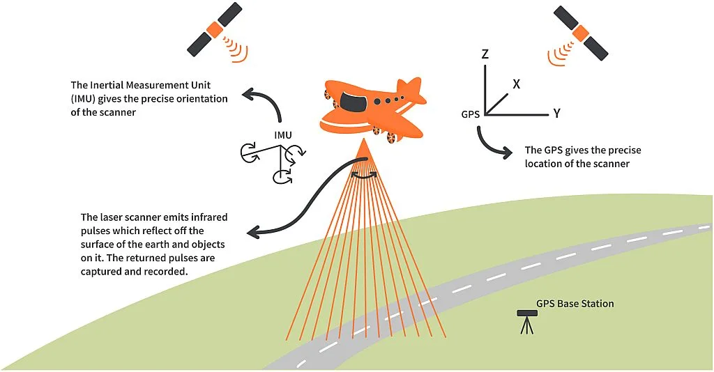
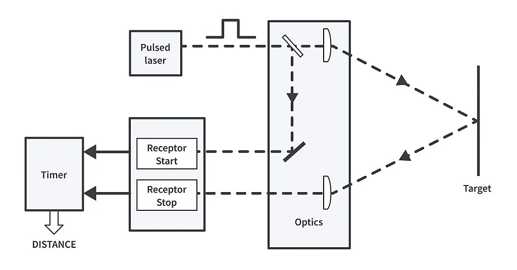
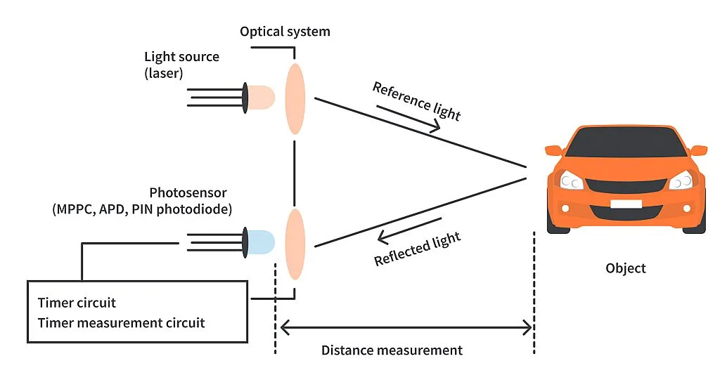
Conventional scanning LiDAR uses a laser beam that illuminates a single point at a time, and is scanned to illuminate the field of view point-by-point. LiDAR uses active sensors that supply their own illumination source. The light hits objects and the reflected energy is detected and measured by sensors. Distance to the object is determined by recording the time between transmission from the source and backscattered pulse detection and by using the speed of light to calculate the distance traveled. It is more precise to say that pulses are backscattered and not reflected, as materials on the Earth’s surface are usually not very reflective compared to mirrors.
Flash LiDAR
In flash LiDAR, the entire field of view is illuminated with a wide laser beam in a single pulse. In both scanning and flash LiDAR, a time-of-flight camera (which resolves the distance between the camera and the subject for each point of the image) is used to collect information about both the 3-D location and intensity of the light incident in every frame. In scanning LiDAR, this camera contains only a point sensor, while in flash LiDAR, the camera contains either a 1-D or a 2-D sensor array, each pixel of which collects 3-D location and intensity information. One of our Friends of CircuitBread, Omron Electronic Components, created a video to visualize both this operation and an application example of their sensor, the B5L Time-of-Flight Sensor, which you can watch here. Flash LiDAR is especially advantageous when the camera or scene or both are moving, since the entire scene is illuminated at the same time. With scanning LiDAR, jitters can cause inaccuracies from the lapse in time as the laser rasters over the scene. Flash LiDAR produces more accurate imaging because captured points do not need to be pieced together, and the system is not sensitive to platform motion. This results in less distortion.
LiDAR systems allow scientists and mapping professionals to examine both natural and manmade environments with accuracy and flexibility. Scientists are using LiDAR to produce more accurate shoreline maps, make digital elevation models for use in geographic information systems, to assist in emergency response operations, and in many other applications.
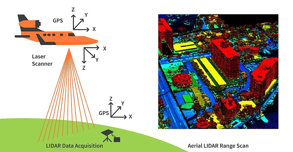
Based on the platform, LiDAR applications can be divided into airborne and terrestrial types. The two types require scanners with varying specifications based on the data's purpose, the size of the area to be captured, the range of measurement desired, the cost of equipment, and more. Spaceborne platforms are also possible.
Airborne LiDAR
Airborne LiDAR is installed on a helicopter or drone for collecting data. As soon as it’s activated, Airborne LiDAR emits light towards the ground surface, which returns to the sensor immediately after hitting the object, giving an exact measurement of its distance. Airborne LiDAR is further divided into two types — Topological LiDAR and Bathymetric LiDAR. Topographic LiDAR typically uses a near-infrared laser (800 to 2,500 nm) to map the land, while bathymetric LiDAR uses water-penetrating green light (495–570 nm) to measure seafloor and riverbed elevations.
Terrestrial LiDAR
Unlike Airborne, Terrestrial LiDAR systems are installed on moving vehicles or tripods on the earth's surface for collecting accurate data points. These are quite common for observing highways, analyzing infrastructure or even collecting point clouds from the inside and outside of buildings. Terrestrial LiDAR systems have two types — Mobile LiDAR and Static LiDAR. Mobile lidar systems can include any number of LiDAR sensors mounted on a moving vehicle to collect data along a path. Static LiDAR is the collection of data from a static location with sensors typically mounted on a tripod. These systems can collect LiDAR data inside buildings as well as exteriors.
APPLICATIONS
Some compelling applications of LiDAR technology include:
Land Surveying
LiDAR sensors can be attached to drones to generate 3D digital terrain models of remote or rough areas for land surveying. For forestry and farming, LiDAR-equipped drones can be deployed to survey farms to help determine how resources can be utilized to maximize productivity. They can also be used to create 3D models of forest areas that show the impact of human activity.
Mining
LiDAR is an excellent instrument for calculating volumes of material present in open pit mines without disrupting work on the ground. Integrating drones into mining workflows saves time, costs, and reduces risk exposure.
Law Enforcement
LiDAR speed guns are used by the police to measure the speed of vehicles and enforce speed limits. In forensic investigations, scans of crime scenes record exact details of object placement, blood, and other important information for review and analysis. In cases of shootings, scans can also be used to determine bullet trajectory.
Physics and Astronomy
The functionality and accuracy of LiDAR systems were first proven in 1971 during the Apollo 15 mission, when astronauts used a laser altimeter to map the surface of the moon. Since then, LiDAR technology has secured its significance in physics and astronomy. A LiDAR instrument in a Mars-orbiting satellite was used to produce a precise topographic survey of the planet. LiDAR is used as a remote detection instrument to measure densities of components of the atmosphere, such as potassium, sodium, nitrogen and oxygen. These measurements can be used to calculate temperatures.
LiDARs have been in existence since the 1960s. Advancement in technology has made its applications diverse nowadays. LiDAR technology is now used in the fields of automation, agriculture, archeology, quantifying atmospheric components and many other fields while also being a useful tool in scientific research.
